File:Elam Map.jpg
From LDS Sunday School
Error creating thumbnail: Unable to save thumbnail to destination
No higher resolution available.
Elam_Map.jpg (300 × 250 pixels, file size: 28 KB, MIME type: image/jpeg)
Map showing the area of the Elamite Empire (in red) and the neighboring areas. The approximate Bronze Age extension of the Persian Gulf is shown.
Permission is granted to copy, distribute and/or modify this document under the terms of the GNU Free Documentation License, Version 1.2 or any later version published by the Free Software Foundation; with no Invariant Sections, no Front-Cover Texts, and no Back-Cover Texts. A copy of the license is included in the section entitled "GNU Free Documentation License".
File history
Click on a date/time to view the file as it appeared at that time.
| Date/Time | Thumbnail | Dimensions | User | Comment | |
|---|---|---|---|---|---|
| current | 11:28, 15 October 2006 | 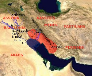 | 300 × 250 (28 KB) | Reds0xfan (talk | contribs) | Map showing the area of the Elamite Empire (in red) and the neighboring areas. The approximate Bronze Age extension of the Persian Gulf is shown. Permission is granted to copy, distribute and/or modify this document under the terms of the GNU Free Docume |
- You cannot overwrite this file.